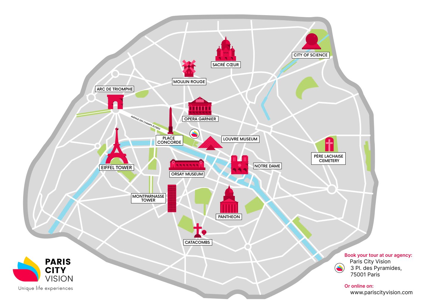
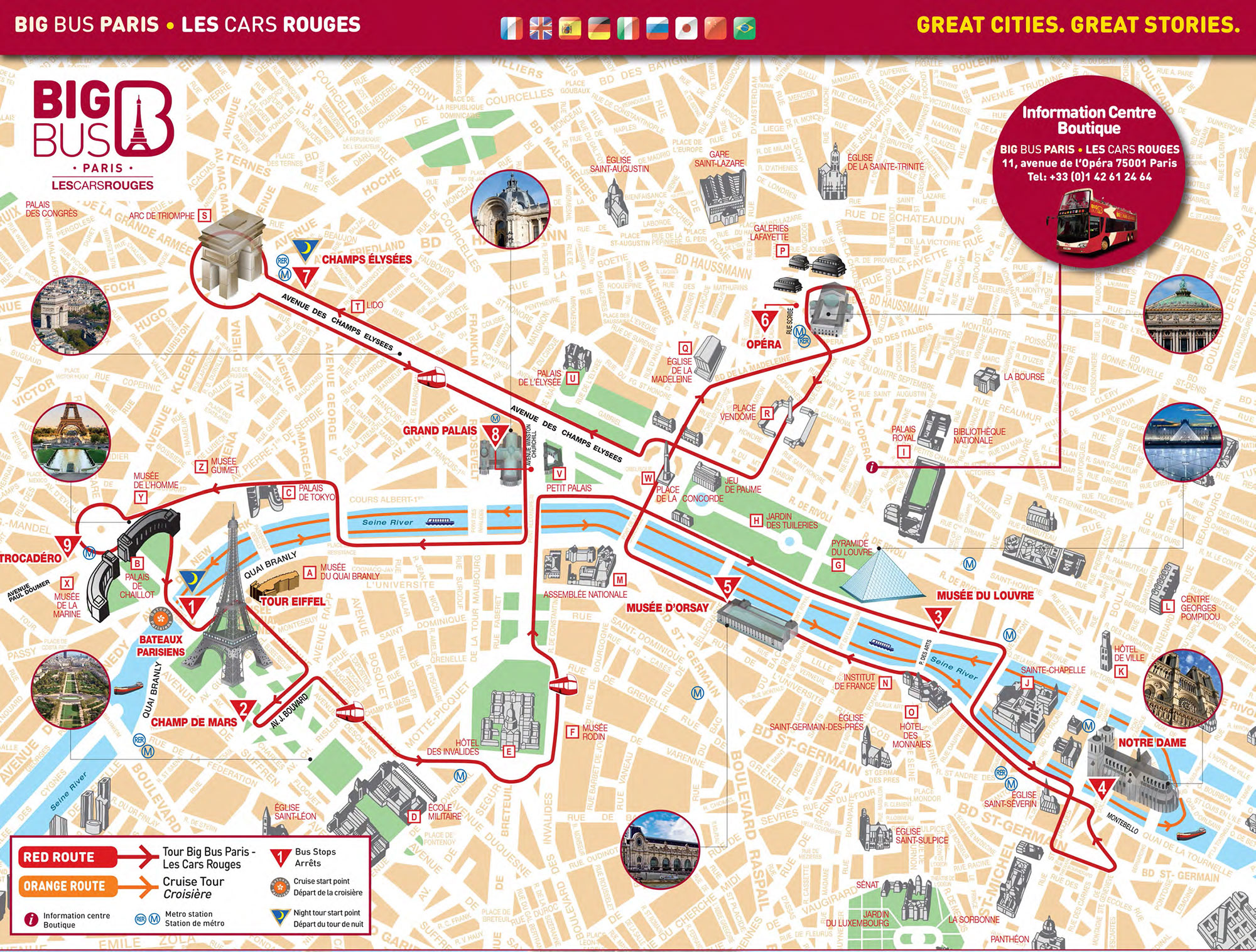
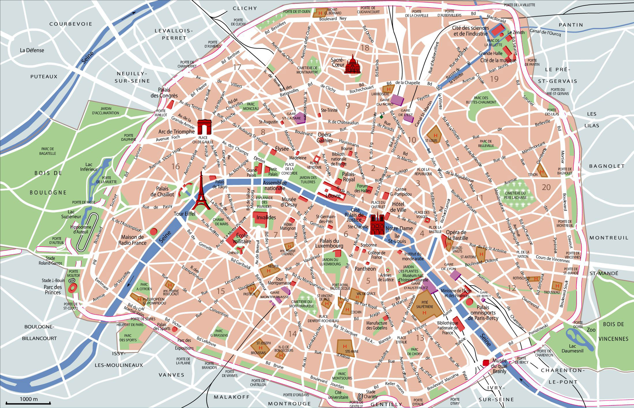
Planning a trip to Paris can be exhilarating but overwhelming at the same time, especially when it comes to navigating the city’s historic streets and vibrant neighborhoods. In this guide, we’ll delve into everything you need to know about using a Paris map as a tourist. From iconic landmarks to hidden gems, personal travel experiences, and practical tips, we’ve got you covered. Let’s embark on this journey through the enchanting streets of Paris!
Understanding Paris: A City of Arrondissements
Paris is divided into 20 administrative districts known as arrondissements. Each one has its own unique charm, character, and attractions. Familiarizing yourself with these can significantly enhance your travel experience. A well-detailed Paris map can help you identify which arrondissement you’re in and what you can explore nearby.
Overview of Arrondissements
| Arrondissement | Main Attractions | Highlights |
|---|---|---|
| 1st | Louvre Museum | Historic architecture, shopping at Rue de Rivoli |
| 2nd | Palais Brongniart | Charming boutiques, cafes |
| 3rd | Picasso Museum | Le Marais district, lively atmosphere |
| 4th | Notre-Dame Cathedral | Historic sites, Seine River views |
| 5th | Panthéon | Latin Quarter, Sorbonne University |
| 6th | Luxembourg Gardens | Peaceful walks, stunning flowers |
| 7th | Eiffel Tower | Iconic views, Seine river cruises |
The Importance of Having a Tourist Map in Paris
Having a reliable map is crucial for a seamless experience in Paris, particularly for first-time visitors. Here are a few reasons why:
- Orientation: It helps you understand the layout of the city and locate important landmarks.
- Localized Insights: A good map highlights local eateries, shops, and attractions that you might miss otherwise.
- Walking Routes: Paris is best explored on foot, and a map provides the best walking routes to discover hidden gems.
Mapping Out Your Paris Adventure
Let’s break down how to use your Paris map effectively during your trip.
Choosing the Right Type of Map
When selecting a map, consider the following options:
- Printed Maps: Often available at tourist information centers, hotels, and airports. While they’re less interactive, they can be handy for quick references.
- Digital Maps: Apps like Google Maps or Citymapper allow you to navigate efficiently. They provide real-time traffic updates and public transport options.
- Tourist Maps: Specialized maps usually highlight major attractions and are designed for visitors. They are typically available in multiple languages.
Tips for Using Your Map
Here are some personal tips based on my travels in Paris:
- Mark Key Locations: As you plan your itinerary, mark locations on your map. This will help streamline your day.
- Learn Basic French Phrases: Knowing how to say basic phrases can help you ask for directions if needed!
- Check Surroundings: Before heading out, familiarize yourself with the surrounding area on the map. It helps in understanding your route better.

Must-Visit Attractions in Paris
With your map in hand, let’s explore the landmarks you absolutely cannot miss.
Eiffel Tower
No visit to Paris is complete without a trip to the Eiffel Tower. Standing tall at 1,083 feet, this iconic structure offers breathtaking views of the city.

Louvre Museum
The Louvre is the world’s largest art museum and a historic monument. It’s home to thousands of works, including the Mona Lisa and the Venus de Milo.
Notre-Dame Cathedral
Despite the destruction from the fire in 2019, Notre-Dame remains a symbol of Paris. Explore the surrounding Île de la Cité, and enjoy the Seine’s beauty.

Montmartre and Sacré-Cœur
This bohemian district offers charming streets, artists, and the stunning Sacré-Cœur Basilica. The views from the top are worth the climb!
Champs-Élysées and Arc de Triomphe
This iconic avenue is perfect for a leisurely stroll. Be sure to visit the Arc de Triomphe for rich history and panoramic views.

Advantages of Using a Tourist Map
Here are some pros and cons of utilizing a tourist map during your Paris journey:
Pros
- Gives a comprehensive overview of major attractions.
- Helps avoid getting lost, especially in the winding streets of Paris.
- Can be used offline (in case of poor mobile reception).
Cons
- May not include every new restaurant or attraction.
- Can feel overwhelming with too much information.
- Some maps can quickly become outdated if they don’t keep up with changes.

Travel Essentials for Navigating Paris
To enhance your experience, consider packing the following essentials:
- Portable charger for your devices.
- Comfortable walking shoes.
- A small notebook for jotting down notes or experiences.
- Language translation app for ease of communication.
Exploring Parisian Transportation Options
While a map will help greatly, knowing how to navigate the transportation system is equally important.

Metro System
The Paris Metro is a convenient way to get around. Familiarize yourself with the main lines and stations, and use your map to find your way.
Buses and Trams
Consider taking buses or trams for a more scenic route. They often stop near major landmarks, making it easier to hop on and off.

Biking and Walking
Paris is an extremely walkable city. Alternatively, use bike-sharing services like Vélib’ to explore in a unique way.
Best Paris Map Products for Tourists
Investing in a high-quality Paris map or app can enhance your travel experience immensely.
Top Recommendations
| Map/Product | Type | Rating | Price | Key Features |
|---|---|---|---|---|
| Paris City Map (Print) | Printed | 4.5/5 | $12.99 | Durable, waterproof, includes top attractions. |
| Google Maps (App) | Digital | 4.8/5 | Free | Real-time navigation, public transit info, offline maps. |
| Rick Steves Paris Map | Printed | 4.7/5 | $9.99 | Custom routes, highlights off-the-beaten-path locations. |
| Paris Map & Guidebook | Combination | 4.6/5 | $19.99 | Includes cultural insights and tips for visitors. |
Frequently Asked Questions About Paris Maps for Tourists
What is the best way to navigate Paris as a tourist?
The best way to navigate Paris is to use a combination of a physical map and a digital app like Google Maps. This way, you have both a reliable reference and real-time updates on transport options.
Are tourist maps available in multiple languages?
Yes, many tourist maps are available in multiple languages, particularly at tourist information centers and hotels. Look for maps labeled as “multilingual.”
Can I find free maps in Paris?
Absolutely! Many tourist information centers offer free maps that highlight key attractions and public transport routes. It’s a great way to start your exploration.
How can I use public transport easily in Paris?
Using apps like Citymapper can simplify public transport navigation. Make sure to download it before you arrive, and familiarize yourself with the metro and bus lines for easier travel.
Final Thoughts: Embrace the Parisian Adventure
Navigating Paris with a map opens up a world of exploration that you won’t want to miss. The city is filled with history, culture, and local treasures waiting to be discovered. As you wander through its charming streets, remember that getting lost can sometimes lead you to the best experiences! Happy travels!