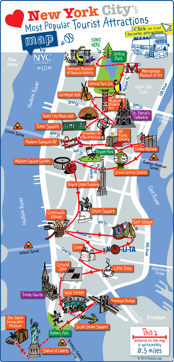
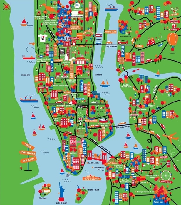
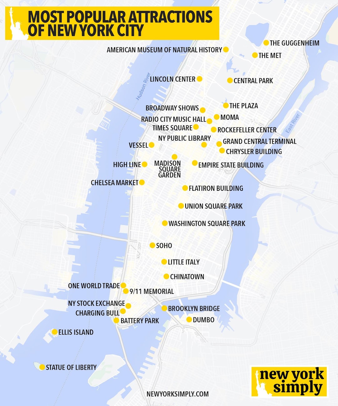
New York City, often referred to as the Big Apple, is one of the most iconic destinations in the world. With its vibrant neighborhoods, iconic landmarks, and bustling streets, navigating this metropolis can be a bit overwhelming for first-time visitors. That’s where a good map comes in! In this comprehensive guide, we’ll dive into everything you need to know about using maps in New York City, enhancing your travel experience to the fullest.
Why a New York Map is Essential for Tourists
When visiting a city as large and diverse as New York, a map serves as your best friend. Here are a few reasons why:
- Navigation: With countless streets, subways, and avenues, a map helps you find your way around.
- Attractions:** Locating major tourist spots becomes easier when you can visualize their locations.
- Planning:** A map allows you to plan your itinerary effectively, ensuring you don’t miss any must-see attractions.
- Discovering Hidden Gems:** Maps often highlight lesser-known spots, giving you a taste of local culture.
Types of Maps for NYC Tourists

Before you start exploring, it’s crucial to know the different types of maps available for tourists. Each type offers unique benefits:
1. Digital Maps
Digital maps, such as Google Maps or Apple Maps, are convenient and updated in real time. They can help with:
- Public transportation routes
- Traffic conditions
- Nearby attractions and restaurants
2. Printed Maps
While digital maps are helpful, printed maps provide a tactile experience. Here are a few types of printed maps you can find:
| Type | Best For | Where to Get |
|---|---|---|
| City Tourist Map | General navigation | Visitor centers, hotels |
| Subway Map | Public transportation | Subway stations, online |
| Neighborhood Guides | Local attractions | Local bookstores, tourism websites |

3. Themed Maps
Some maps focus on specific interests, such as food, art, or history. Using these maps can uncover NYC’s hidden treasures based on your preferences!
Using Public Transportation: A Tourist’s Map Guide

New York City’s public transportation system can be daunting, but with the right map, you can navigate it like a pro. Here’s what you need to know:
Getting a Subway Map
The subway is one of the fastest ways to get around. You can easily access the subway map on your smartphone or obtain a printed version at any subway station. Here are essential tips:

- Look for the “MTA Subway Map” poster in stations or download the MTA app.
- Familiarize yourself with the color-coded lines, as they represent different subway routes.
- Check train schedules and service updates, especially on weekends.
Bus Maps: A Different Perspective
Using buses can also be an enriching experience. Here’s how to make the most of it:

- Obtain a bus map from the MTA or download it online.
- Keep track of bus stops, which are marked by signs displaying the route number and name.
- Consider using the MTA Bus Time feature to track buses in real time.
Top Tourist Attractions Mapped Out

New York is brimming with iconic attractions. Here’s a quick map overview of some must-see spots:
Central Park
Perfect for a leisurely day outdoors, Central Park’s vast green spaces are an oasis in the city. With trails, lakes, and park benches, this map will help you find:
- The Central Park Zoo
- Strawberry Fields
- Belvedere Castle

Times Square
The vibrant lights and electrifying atmosphere of Times Square can be overwhelming. A map will help you navigate:
- Theater district
- Nearby restaurants
- Popular photo spots
Statue of Liberty
To visit Lady Liberty, you’ll need to catch a ferry from Battery Park. A map will guide you through:
- Ferry schedules
- Nearby attractions such as the 9/11 Memorial
The Metropolitan Museum of Art
Cultural enthusiasts shouldn’t miss the Met! Use a museum map to explore:
- Different wings
- Current exhibitions
Travel Tips for Maximizing Your New York Map Experience
Now that we’ve covered types of maps and essential attractions, here are some travel tips to enhance your journey:
1. Get a Local SIM Card
Having a local SIM card will ensure you have access to GPS and maps without worrying about data charges.
2. Mark Your Favorites
Before your trip, identify and mark your favorite spots on your digital map. This saves time when planning your itinerary.
3. Download Offline Maps
Apps like Google Maps allow you to download areas for offline access, ensuring you won’t get lost even without cellular service.
Exploring NYC Neighborhoods: A Mapping Adventure
Each NYC neighborhood has its unique vibe. Use a neighborhood map to discover:
1. Manhattan
The heart of NYC is packed with iconic sites. Explore neighborhoods like:
- Upper West Side: Known for its cultural landmarks.
- SoHo: Famous for shopping and art galleries.
2. Brooklyn
Crossing the Brooklyn Bridge opens up a world of exploreable neighborhoods:
- Williamsburg: A hub for hipsters and artists.
- DUMBO: Offers stunning views of Manhattan.
3. Queens
Diverse and culturally rich, Queens offers various cuisines and parks:
- Astoria: Known for its Greek tavernas.
- Flushing: A hotspot for authentic Asian food.
Pros and Cons of Using Maps in NYC
Pros
- Easy navigation
- Access to lesser-known attractions
- Planning and organization of your itinerary
Cons
- Digital maps can drain your battery
- Printed maps can be cumbersome to carry
- Too many options can overwhelm first-time visitors
Product Recommendations: Best Maps and Guides for NYC
When it comes to choosing the best maps and guides for New York City, here are some top-rated products along with reviews and ratings:
| Product | Rating | Price | Features |
|---|---|---|---|
| Streetwise New York City Map | 4.7/5 | $7.99 | Durable, laminated, detailed street info |
| National Geographic New York City Guide | 4.5/5 | $18.99 | Cultural insights, detailed maps |
| DK Eyewitness New York City | 4.6/5 | $24.99 | Visual guide with excellent maps |
These products are highly rated on platforms like Amazon and are perfect for both first-time visitors and seasoned travelers.
FAQs About Traveling with a New York Map
1. Are physical maps still relevant in the digital age?
Yes! While digital maps are convenient, physical maps provide a great backup option and can help you get oriented without draining your phone’s battery.
2. How do I access New York City subway maps?
You can easily find subway maps online, on the MTA’s official website, or at subway stations throughout the city.
3. Can I use Google Maps offline in NYC?
Yes! You can download specific areas of Google Maps for offline use, which is helpful when navigating without cellular data.
4. What’s the best way to get around New York City?
The subway is often the quickest and most efficient way to get around Manhattan and beyond. However, buses and rideshares are also viable options depending on the area.
5. Where can I find tourist maps in NYC?
Tourist maps can be found at visitor centers, hotels, and various attractions throughout the city. Many are also available for download online.
Conclusion: Your Journey Begins Here!
As you prepare for your adventure in New York City, remember that a good map is your trusty companion. Whether you opt for a digital or printed version, having a clear understanding of the city layout will undoubtedly enhance your travel experience. From iconic landmarks to hidden gems, let your maps guide you to the unforgettable memories waiting around every corner.